Some sun, mainly cloudy ..... we’ll see ... about 14 degrees
Today we were up and at em and out of the apartment just before 7am. We’re off on the big one - a long day trip to Doubtful Sound.
To get there involves a fair bit of travel. This is not by choice, to extend the trip for tourists, as it were. This is the ONLY way to get to Doubtful Sound.
We are picked up by coach at 07:15 and travel 20 - 30 mins to Lake Manapouri.
We climb aboard a $5m catamaran (Capt is very proud) at the Pearl Harbour marina on the Waiau river which feeds Lake Manapouri and sail (under 2x1000hp engines - one each side) for 45 mins to the other side of the Lake. This lake covers 142 sq kms and is dotted with 34 islands. We take a photo but don’t know why we bother as this is nothing compared to what lies ahead (we hope).

We arrive at the visitor centre next to the Manapouri Hydroelectric Powerstation. The power station is a man-made wonder which takes advantage of the difference in heights of the mountains between the lake and Doubtful Sound to act as a natural dam. The water then flows out of a 10km tunnel to Deep Cove. The site is inaccessible apart from by boat. What strikes us is the logistics and investment made in constructing this, as everything needs to come by boat, diggers, men, food, buildings, hardware, everything. It is nothing short of astounding. We have an admiration for Kiwi eco-credentials. The turbines run all the time, continuous. If the level of Manapouri Lake drops, it is topped up by Lake Te Anau - largest lake in NZ by surface area (if you were paying attention). Already it is construction on a huge scale.
Then it is revealed the power station was built to power a smelting factory. Not the clean eco-power we thought to power all the homes in South NZ, but a dirty, belching, money making smelter to turn out the finest aluminium for China and Europe. Graham’s dream is shattered.
The Aluminium Smelter is 171 kms to the south, at Bluff. The Aluminium which is the very best quality and in much demand worldwide our driver Malcolm proclaims proudly. There is also some electricity left over to power thousands of homes.

We then get on a coach (which was initially brought across on a barge - in case you were wondering) which will take us on the Wilmot Pass road (not tarmaced) of 22kms - completed in 1965 to facilitate the building of the powerstation. It cost more than $2 per cm to build! You may think that is cheap but all it is, is ground levelled, drained and stones laid. It is, in essence, a farm track.
Malcolm our driver was a mine of information as we travelled this expensive track. He explained how the trees and mosses intertwine on the steep rock cliffsides to make a rainforest of mostly silver beeches. The litchen which grows there can hold 25 times their dry weight in water which explains how the vegetation survives. The mosses appear to form a moss garden on the rock face.
We know because we got personal with the trees near Lake Gunn, the trees do not root in the ground. They root above ground. First comes the lichen clinging onto the rock, then comes the moss clinging onto the lichen, then comes the low growth, then come the trees. If there is a heavy rain the trees can dislodge and the have a tree avalanche leaving bare rock for the whole process to start again. We see several examples of this during the sail.

This tree is thousands of years old .. says Malcolm
We pass by the Cleve Garth Falls at 365m ( 1,200 ft) high above the pass road.

We slowly made our way up to the 670m ( 2,200 ft) summit and then down the 1:5 slope to Deep Cove - our access to Doubtful Sound.
Deep Cove hides the 10 km underground tunnel (!!) under the mountains where the outflow from the power station feeds the sound.
We climb aboard our boat - our home for 3 hrs.

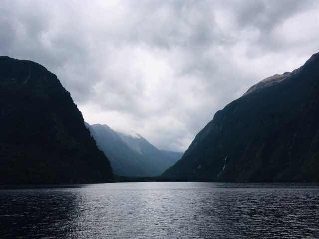
and set off to explore Fiordlands second largest 40 km( 25 miles) long fiord and the deepest at 421m (1,380 ft) ! We now know why this area is so wet! It rains 2m a year at our motel in Te Anau and between 8m and 10m a year at Doubtful Sound - that’s a lot of water!! (9m equates to 354 inches, but it doesn’t rain everyday). Our guides happily tell us that we are lucky as it has been raining the last few days (really?) as therefore the waterfalls tumbling down the rockface along the sound will be even more spectacular! We’ve never met so many people who claim they like rain as much as these folk in Fiordland!

Kayakers getting up close to the waterfalls

It was misty.. atmospheric you could say as we made our way almost to the Tasman Sea and very very windy. Very rolly polly. The weather was seriously against us as the wind picked up and the swell increased - our captain decided not to go any further. He explained what we already know: the Southern Ocean has no land mass to break up the waves, it just goes round and round, 360 degrees.
This seems a good time to answer the question. How did Doubtful Sound get its name? Well, it was named by Capt James Cook, who was one of the world’s great sailors, no mug. He was sailing by in 1770 wanting to make land but doubted if he entered whether he could get out again. His ship, the Endeavour (launched in Yorkshire did you know) had a speed of around 7 knots, with little ability to go upwind (modern yachts can tack 45’ into the wind, he could not). He decided not to enter, and named the sound Doubtful Sound on his chart. We, however, in our 2,000+hp, 30knot monster can go where we like. So, the big question. Could Cook have got out again if he went in? Well....... it’s doubtful.
He did however sail into another sound - Dusky Sound - just noting the entrance on his 1770 voyage calling it Dusky Bay - but did sail into it on his next trip. We have also discovered Dusky Sound but the one we love is a very tasty Pinot Gris - the wine that is!

Next stop: Argetina. These are the “ hares ears” - indicating the entrance to the Tasman sea.
As you can see we zoomed in to get them - the sea was not looking too friendly.
We passed by a hut like building - apparently used by fishermen very occasionally for big parties! but it also has a helipad.
It serves as a refuelling point and a refuge in bad weather. The most western inhabited building in New Zealand ( temporarily)

The Blanket Bay Hotel!
In the middle of the sound the captain cut the engines, requested silence for several minutes and we all just relished this bit of wilderness and calm.
We cruise around the Sound and its many fingers. The views are amazing we just hope the camera conveys a little of what we saw.


On the way back. That californian state park wooly hat souvenir certainly came in handy for Carol! And then back to dry land.

We retrace our steps back to Te Anau the way we came. Te Anau was bathed in sunshine - is the fiords which are permanently in rain or just timing. Who knows.
Tomorrow we have a glow worm extravaganza, and then on to Wanaka, a lakeside town, gateway to Mount Aspiring National Park.
No comments:
Post a Comment